DEVELOPMENT OF NATIONAL SPATIAL DATA INFRASTRUCTURE IN KOREASangdeuk HAN and HeungMuk CHO, KoreaKey words: Geographic Information System(GIS), National Spatial Data Infrastructure (NSDI), Framework data, Digital maps. AbstractThe Korean government has initiated a full-scale implementation of the Master Plan of National Geographic Information System (NGIS) in 1995. The success of the 1st Master Plan of NGIS marks a turning point in the physical management system of our land. The Master Plan of NGIS includes generation of spatial databases for NGIS, establishment of data standardization, assistance of GIS-related technical development and development of framework for utilization and application of NGIS. The NGI (National Geography Institute) plays a crucial role in surveying and mapping activities, and responsible for the Geographic Information Subcommittee of the Steering Committee in the Master Plan of NGIS. In order to come along with National project, the NGI has already expanded its organization and members. The progress has rapidly been achieved in the generation of national digital base maps, underground utility maps and thematic maps. The first phase of the Master Plan of NGIS will be completed by the year of 2000. The main purpose of the first phase is to establish basic GIS infrastructure such as to produce various kind of digital maps. The second phase of the NGIS which is start from 2001 through 2005 is to the spread of GIS application, maintain the digital maps. During the second phase of NGIS the NGI has planed to updating the digital maps and provide framework data. And also to contribute the implementation of the regional and global Spatial Data Infrastructure as Asia-Pacific Spatial Data Infrastructure (APSDI) and GSDI, the NGI will be closely cooperate with the member countries of PCGIAP and GSDI. 1. INTRODUCTION1.1 Background of NGISNo sector of the world today is untouched by the wave of information technology. Land information is no exception and has rapidly been informationized owing to the development of computers and ever-increasing demands for land information. The main purpose of informationizing land information is the efficient use and management of land. Land is not only the object of economic development but also the object of preservation for a pleasant environment. In this information era, Korea is devoting much time and energy to establish an information system in the land-related sector. To create the land-related information system, what is needed is a comprehensive and efficient means of management. Geographic Information System (GIS) which meets the needs of this information era, is considered as an ingenious device that makes the efficient management of land possible. Korea became increasingly aware of the importance of the GIS for various fields such as urban management, disaster prevention and infrastructure management and environment protection, etc. In addition, the GIS is being more and more frequently used in administrative affairs including distribution of land information and public welfare services. Under this trend, this GIS will undoubtedly become a valuable social overhead capital in the 21st century. Even though the GIS is still unfledged in Korea, it is well recognized that we must develop a National Geographic Information Infrastructure and foundation for the effective distribution and application of Geographic Information. The master plan for National Geographic Information System (NGIS) of Korea which was initiated and designed by Central Government, will play a decisive role in our National GIS Development Program. On May 1995, the Korean government has implemented "A Master Plan of National Geographic Information System(NGIS)" in order to develop the information infrastructure for geo-spatial data management. Since then, the GIS data compilation work in various sectors is successfully making headway. There is a wide recognition of the necessity for the legal supporting system to ensure the implementation of NGIS. Therefore the NGIS law and regulation enacted in January 2000 has take effect from July 2000. 1.2 Objectives of NGISThe Korean government has initiated a full-scale implement of the NGIS Master Plan in 1995. The GIS data compilation work in various sectors is successfully making headway. The national digital basemaps has been rapidly progressed. Plans for digital underground utility and thematic maps are also underway. Furthermore, the local autonomous groups are promoting the use of GIS in various fields including the management system for urban areas and facilities. The goal of the NGIS master plan is to develop environmentally healthy and pleasant land as well as to promote national competitiveness and productivity. It is expected the success of the NGIS Master Plan to mark a turning point in the management system of our land. The major issues of the NGIS Master Plan can be categorized as follows:
2. DEVELOPMENT STRATEGIES FOR THE NGISCurrently, the Korean government plays a major role in the NGIS, especially in the area of the development of spatial database and the standardization of spatial data. Technology development and training of GIS specialists are also considered as one of the major of government. The overall objectives of the NGIS are i) to establish a geographic information infrastructure in Korea, and ii) to eliminate unnecessary duplicate investment for GIS. To achieve the objectives of NGIS, the NGIS Steering Committee developed the following phase-by-phase strategies: Phase 1 (1995~2000): GIS Infrastructure foundation period
Phase 2 (2001~2005): GIS data utilization period;
Phase 3 (2006~): GIS exploitation period by completing arranging the national spatial data infrastructure and diffusing GIS generally; 3. THE STRUCTURE OF THE NGIS COMMITTEETo proceed and implement the first five-year master plan, among 11 Ministries in Korea, Ministry of Construction and Transportation (MOCT) plays a leading role in the NGIS master plan. The vice minister of MOCT is chairing the NGIS steering committee. Under the steering committee, there are 5 subcommittees and an advisory board. These subcommittees for NGIS development have already been in operation and the central government is currently involved in each subcommittee. The followings is the brief description of each subcommittee during the 1st NGIS Master Plan period (1995~2000):
The NGIS committee structure during the period of the first master plan has the coordination problem because 12 different ministries were involved in the GIS development. And the structure of NGIS committee was inappropriate to take up the newly emerging issues such as the establishment of clearinghouse and distribution network, GIS industry promotion, human resource development, etc. In this regard, the NGIS committee structure was reformed in 2000 and the level of NGIS Steering Committee has been up-positioned to the Minister of Construction and Transportation. Under the NGIS steering committee, there were established following 7 sub-committees in the 2nd NGIS Master Plan period(2001~2005):
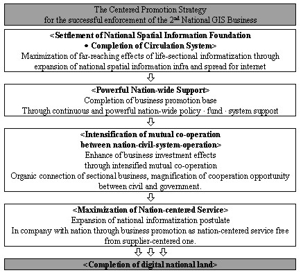
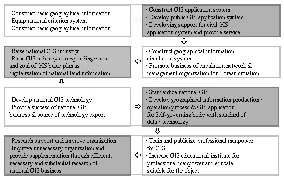
4. THE SECOND MASTER PLAN OF THE NGISTo accomplish the master plan effectively and efficiently, the NGIS steering committee selected several major tasks and projects; a) national framework database, b) development of integrated underground facilities management system, c) development of thematic maps and public utilization system, d) establishment of national clearinghouse, e) standardization of geographic information, f) GIS human resource development The figure 1 and 2 are a promotion strategy and plan of the second master plan, respectively
Figure 1. Promotion Strategy
Figure 2. Classified Promotion Plan 4.1 Establishment of National Framework Data baseFramework data is the fundamental data set as a basic and reference map to which specific information can be added for the respective purpose of diverse GIS application areas. As a first step of establishing national framework data base, National Geography Institute (NGI) with local governments focused on the digitalizing of the national base maps, which is scales 1:1,000, 1:5,000, 1:25,000, since 1995. The digitalization of base map completed by the end of 2000.
The 79 major cities had digitized by the year of 1999 with total number of map sheets of 12,428. The central and local government are responsible for the even investment. Since 1995, the 1:1,000 digital map was made by the NGI. For the 1:1,000 scale maps, the photogrammetric technique is mainly implemented for the digital mapping. However some of these maps had digitized through scanning the existing maps.
The 1:5,000 scale map is the topographic base map, which is planned to cover the whole country. The covering areas are about 70,000 and total number of map sheets is 16,200. the NGI are responsible for the generation of 1:5,000 digital mapping. the NGI has a full responsibility of the maintenance and updating the whole 1:5,000 digital map. The central government and 7 government-affiliated companies are investing the generation of 1:5,000 digital maps. The 1:5,000 maps are digitized through the combination of scanning the existing maps and the photogrammetric techniques. The total 16,194 sheets of 1:5,000 Scale Digital Map were produced in 2000.
The 1:25,000 scale maps will be digitized, especially for the mountainous areas. But the NGI had changed the plan to cover the whole country. Since 1991, there were 750 map sheets generated. The total number of map sheets will be 768.
In the second master plan, it has introduced a new concept for the NGIS base map that is a framework data. It is required urgently to build the national framework data. The national framework data is the skeleton of diverse spatial information capable of overlapping and adding spatial data, both schematically and spatially upon need basis. Therefore the phase 2 NGIS master plan(2001~2005) will focus on the establishment of framework data base as follows;
In making a selection of framework data in theme, the following elements shall be considered;
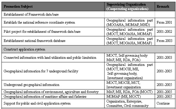
In 2001~2002, the pilot project will be carried under direction of NGI which held Geographic information subcommittee. The aim of these pilot project is to develop strategies, guidelines, standardization for framework data. From 2003, the main project will be started to use the results of pilot project. 4.2 Underground Facilities Management SystemThe gas explosion accidents in Seoul and Taegu in 1994 and 1995 respectively has accelerated the development of underground facilities management system. The Korean government started to develop integrated underground facilities management systems in 7 areas as sewerage, water, communication, gas pipelines, electricity lines, heating and oil pipeline. To work out efficiently and effectively, Kwachon pilot project has started in August, 1996 and finished on April 1997, sponsored by the Ministry of Construction and Transportation as one of NGIS major project. Achievements in the pilot project in Kwachon are as follows;
With the experience and results from Kwachon pilot project, the NGIS Steering Committee decide to have 19cities develop integrated underground facilities management system until the end of 2002 and further extend to all the cities cross the country. 4.3. Utilization and Clearinghouse for national spatial data distributionThe first NGIS master plan mainly focused on building the foundation and circumstances of GIS infrastructures. As part of GIS infrastructure foundation, the different categories of digital maps had been developed: topographic maps, thematic maps - road network map, land use map, urban planning map, etc. However, one of the serious problems encounters during the first master plan period was that there was no spatial data distribution network and clearinghouse. Therefore, the second master plan aims to maximize of utilization the already established spatial information by establishing clearinghouse and distribution network for national spatial data. In this regard, the NGIS Steering Committee plans to establish the clearinghouse and distribution network. 4.4 Standardization of Geographic InformationThe first stage implementation of the NGIS Master Plan was completed during the period from 1995 to 2000. Under the umbrella of the steering committee, there were 5 subcommittees (administrative, geographic information, GIS technology, GIS standards and cadastral information) and an advisory board. The GIS standards subcommittee was responsible for defining geographic information standards. During the course of this work, the geographic information standards established by GIS standards subcommittee took account of ISO standards, keeping pace with the international community In the first stage of the NGIS master plan, the standards for geographic information were driven in two different areas:
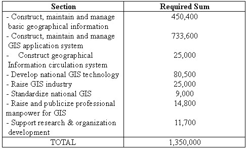
Geographic information production The National Geography Institute (NGI) played a key role in defining the standards in geographic information production. A total of ten of standards were established in this area (including national base map, underground utility map and thematic map). Geographic information distribution/application Two standards were established in this area (including a temporary metadata standard and a data exchange standard (SDTS)). These standards aimed at exchanging and searching the geographic data produced by many different organizations and agencies. For the second stage of the NGIS plan starting in 2001, the strategy and plan on national standards are being arranged to cope with recent technology development, as well as to meet the wide range of customers' requirements. 4.5 Technology DevelopmentFor the development of GIS technologies, approximately US$22.75 million was allocated during the first 5 year master plan. Technology development has been in made for area; i) GIS system integration technology, ii) Mapping, iii) DB tool; iv) GIS application software. 4.6 Human Resource DevelopmentHuman resource development issues are also indispensable element to realize the objectives and goals of NGIS. The NGIS committee is going to increase professional manpower who are involved in NGIS activities, both in government and business. GIS professional manpower training for has been done mainly in university, government run training institute and business institute. As a part of increasing professional manpower training, the NGIS committee is also considering to develop virtual GIS training center which provides cyber-training course through internet. 4.7 Computation of Investment ScaleShare the investment source for the public and civil partnership and induce investment to the civil section. Procurement plan for financial resources such as total investment scale, sectional investment scale and share with civil section will be promoted after consultation with connected section such as the Ministry of Planning and Budget. Table 1. Estimated Investment (Unit : Million WON)
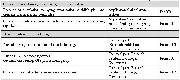
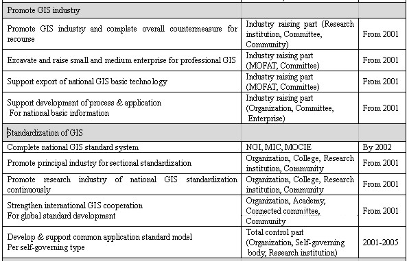
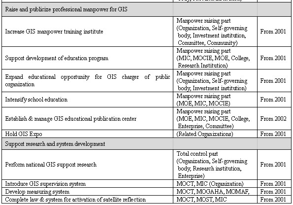
4.8 Promotion Organization per Theme
4.9 Effect valuation for national GIS investmentThis is for maximization of investment efficiency according to completing development plan for the problem through systematic valuation, which is put to practical use of annual expense/effect-analyzing method per sectional investment effect through national GIS business promotion. Applying the valuation result, we derive the problem on plan and business promotion, and take up the reflected and settled plan from the fundamental one. 5. CONCLUSIONThe first phase of the National Geographic Information System (NGIS) Master Plan will be completed by the year of 2000. The main purpose of the first phase is to establish basic GIS infrastructure such as to produce various kind of digital maps. The second phase of the NGIS which is start from 2001 through 2005 is to the spread of GIS application, maintain the digital maps. The main focus of 2nd NGIS master plan are:
These enormous tasks will be proceed in close cooperation between government, academia and private sector as well as international cooperation. During the second phase of NGIS the NGI has planed to updating the digital maps and provide framework data. And also to contribute the implementation of the regional and global Spatial Data Infrastructure as Asia-Pacific Spatial Data Infrastructure(APSDI) and GSDI, the NGI will be closely cooperate with the member countries of PCGIAP and GSDI. REFERENCES
CONTACTSang Deuk Han Heungmuk Cho 14 April 2001 This page is maintained by the FIG Office. Last revised on 15-03-16. |
