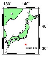
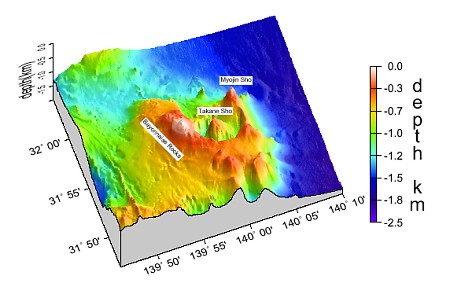
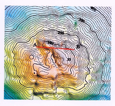
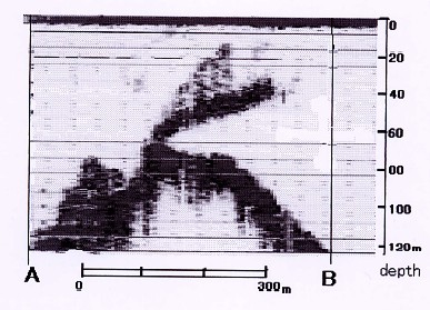
THE SURVEY OF MYOJIN-SHO, THE SUBMARINE VOLCANO BY UNMANNED RADIO OPERATING BOAT "MANBOU II"Kunio YASHIMA, Azuza NISHIZAWA and Yasuo OOTANI, JapanAdditional paper- not presented at the conference, included only in the proceedings. Key words: Manbou, Myojin-Sho, Caldera, Unmanned radio operating survey boat. 1. INTRODUCTIONMyojin-Sho is a submarine volcano on the Izu-Ogasawara Ridge located about 450 kilometers south of Tokyo and about 50 kilometers south of Aogashima Island, which lies at the southernmost rim of the Izu-Shichito Islands (Fig.1). The first eruption was witnessed in 1869, and in the 130 years that followed, more than ten volcanic activities were recorded with repeated cycles of eruption and the appearance and disappearance of a new island. The eruption that took place from 1952 to 1953 was one of its most active volcanic activities on record. The volcanic activity intermittently continued for one year and each volcanic activity created and destroyed an island. The severe explosion in September 1953 finally destroyed the island. The name Myojin-Sho derives from a fishing boat, "No.11 MYOJIN-MARU" of Yaizu City, Shizuoka Prefecture, the crew of which witnessed the first major eruption in 1952. On September 24, 1953, a survey vessel, "No.5 KAIYO-MARU" of the Hydrographic Department of the Maritime Safety Agency investigating Myojin-Sho, met with a shipwreck that took the 31 persons including 9 scientists. This was the biggest disaster in the history of Japanese oceanographic research and an unforgettable tragedy for the Hydrographic Department. Determined to learn a lesson from this tragedy, the Hydrographic Department developed an unmanned radio operating survey boat named "MANBOU" (meaning Sunfish) that could conduct surveys in dangerous sea areas. It has surveyed such dangerous sea areas as submarine volcanoes. In the area around Myojin-Sho, several surveys were carried out after the disaster, but the survey remained fragmentary due to the designation of " Dangerous Volcanic Area " in the nautical chart. Thus, the sea bottom topography around Myojin-Sho remains a mystery to date. However, in 1998 and 1999, the Hydrographic Department conducted comprehensive sea bottom surveys around Myojin-Sho with the newly-built survey vessel "SHOYO" (3,000 tons) and the second generation "MANBOU II" both owned by the Hydrographic Department. As a result of the surveys, the sea bottom topography around Myojin-Sho came clear for the first time. In this paper, the authors report the summary of the surveys and the sea bottom topography around Myojin-Sho. 2. THE HISTORY OF THE SUBMARINE VOLCANIC ACTIVITIES OF MYOJIN-SHOMyojin-Sho (31º56'8" N, 139º59'8" E) is a submarine volcano located on the volcanic front of the Izu-Ogasawara Arc and about 10 kilometers east of the Bayonnaise Rocks (31º55'3" N, 139º54'5" E). The first observation of a volcanic eruption was made in 1869, and during the 130 years since then, more than ten volcanic eruptions and several appearances and disappearances of an island were reported. The volcanic eruption from 1952 to 1953 was one of the biggest volcanic activities on record. The activity intermittently lasted for one year with the appearance and disappearance of a new island repeated with each volcanic activity. The island became 200 meters wide and more than several 10 meters high at a certain point. However, the island disappeared with the severe volcanic explosion that lasted from the end of August to the beginning of September in 1953. Since then, Myojin-Sho has never emerged upon the sea level. The U.S. Navy SOFAR (Sound Fixing and Ranging) Stations off California detected the severe explosion, and Tsunami waves that accompanied the explosion were observed in Hachijojima Island, about 130km north of the Myojin-Sho. The submarine activities continued to take place sporadically until the 1960s. After a 10 year resting period, another eruption was observed in 1970. A discolored water was observed in March 1988. Since then, no other activities have been reported. In this survey, however, a record that suggests a gushing of bubbles near the summit was obtained (Fig.2). The ocean bottom seismograph recorded minor earthquakes, the epicenters of which are located near Myojin-Sho. Thus, the authors consider that volcanic activities continue to take place today though the activity level is low. 3. THE SURVEY BY THE SURVEY VESSEL "SHOYO"AND UNMANNED RADIO OPERATING SURVEY BOAT "MANBOU II"The Hydrographic Department conducted comprehensive sea bottom surveys around Myojin-Sho in September 1998 and January 1999, using "SHOYO" and "MANBOU II". Surveys around specific areas, including the vicinity of the Bayonnaise Rocks, were carried out by the survey vessel "MEIYO" (550 tons) and her small boat. "SHOYO" (3,000 tons) is a state-of-the-art survey vessel, the first diesel power driven vessel of the Hydrographic Department, and came into service in March 1998. She carries new survey instruments such as "MANBOU II", "SEABEAM 2112", the side-scan sonar for deep sea named "ANKOU" (meaning Anglerfish) and the multi-channel seismic reflection equipment. "MANBOU II" (Table 1) is an unmanned radio operating survey boat that measures depth and water temperature and samples water according to preprogrammed instructions. "MANBOU II" conducted the survey in the sea area within a radius of 3 nautical miles (about 5.4 kilometers) of Myojin-Sho. "SHOYO" conducted the survey in the sea area within a radius of about 10 nautical miles (about 18.5 kilometers), but farther than the area of the radius of 3 nautical miles. Bathymetric survey of "MANBOU II", was carried out by using "PDR-601" echo sounder at intervals of about 0.2 nautical miles (about 370 meters) based on the main line set east and west. The surveys of "SHOYO" included multi-beam swath bathymetry, the single-channel seismic reflection, seismic refraction, microseismicity, magnetic and gravity measurements. Bathymetric survey of "SHOYO" was carried out by using "SEABEAM 2112" echo sounder at the intervals of 0.5 nautical miles (about 926 meters) based on the main line set from east to west. "MANBOU II" was used to conduct the survey of the area within 3 nautical miles of Myojin-Sho. This was because the most dangerous phenomenon in a submarine volcanic eruption is the passing of a base surge, and the largest affected areas ever reported worldwide took place within a radius of 4 kilometers. 4. THE SEA BOTTOM TOPOGRAPHY AROUND MYOJIN-SHOIn 1924, a survey vessel of the Naval Hydrographic Office conducted the bathymetric survey in the vicinity of Bayonnaise Rocks. In 1925, nautical chart No. 81 "Izu Shoto Islands" (1:500,000) was published. Hydrographers in those days knew not only the Bayonnaise Rocks but also the existence of submarine volcanoes. Ryoichi MITA, who was killed in the 1953 shipwreck, had the first idea of the sea bottom topography around Myojin-Sho based on the nautical chart and sounding data obtained later. According to Mita (1949), Myojin-Sho was the central cone of a double volcano and the Bayonnaise Rocks was a portion of the somma. In April 1954, after the severe volcanic explosion, a navigational warning was issued to warn ships entering the surrounding area. In July 1972, "Dangerous Volcanic Area" was designated for the area within a radius of 10 nautical miles (about 18.5 kilometers) of Myojin-Sho in nautical charts to restrict vessels from entering. Due to such circumstances, surveys remained fragmentary although surveys were conducted sometimes by the first generation "SHOYO", the first generation "MANBOU" and others. Thus, a detailed and general sea bottom topography around Myojin-Sho remained unknown. In this survey, the authors found that Myojin-Sho is a post caldera cone formed in the northeastern part of the somma of a double volcano(Fig.1). The foot of double volcano lies 1,400 to 1,500 meters in depth and the size is about 30×25kilometers(east-west, north-south). The caldera floor lies about 1,100 meters in depth and the size is10×7kilometers (east-west, north-south). The height of Myojin-Sho from somma is 550 meters and from caldera floor is about 1,000 meters. Myojin-Sho is a single conical cone with the shallowest 50meters in depth. There are depressions near the summit and they correspond to the past eruption site. The central cone of the caldera is the high formerly called Takane-Sho. The height form the caldera floor is 770 meters with the shallowest depth is 328 meters. The Bayonnaise Rocks are volcanic cones made of several rocks, the peaks of which are less than 9.9 meters in height above sea level. Flat terraces are observed at the depth of 30 meters and 120-150 meters. The cone shape of the Bayonnaise Rocks facing the caldera is cut off and no influx objects from the Bayonnaise Rocks are observed in the caldera. Rock samples obtained around Bayannaise Rocks are basalt and the dating by the K-Ar Method suggests 200,000±20,000 years. Therefore, the authors consider that the Bayonnaise Rocks were formed before formation of the caldera, and appeared above sea level before last glacial maximum stage. On the other hand, rock samples obtained around Myojin-Sho is dacite and the cone shape of Myojin-Sho was not cut off by the caldera, and influx objects from Myojin-Sho are observed in the caldera. Thus, the authors consider that Myojin-Sho was formed after formation of the caldera. Based on the data, the authors assume the outline of the topographical development of the sea bottom around Myojin-Sho as follows:
The shallowest depth of Myojin-Sho lies 40~50meters and has been getting deeper: 43 meters (1889), 46 meters (1994) and 50 meters (1999). These values are too deep compared to the values of 14meter (Funka-Asane), 23 meter (Fukutokuoka-no-Ba). The authors assume in the former case, it indicates that the ending of a major volcanic activity has cooled the volcano and caused its volcanic dome or spine to sink in. On the other hand, in the latter case, it indicates the wave base (base of vigorous abrasion). APPENDICESTable 1. Principal particulars and survey/observation itemsof "MANBOU II"PRINCIPAL PARTICULARS
SURVEY/OBSERVATION ITEMS
Fig. 1 Location of Myojin-Sho and the Bird's Eye View of the Sea Bottom Topography around Myojin-Sho
Fig.2 Acoustic record near the summit of Myojin-Sho by "MANBOU II" REFERENCESMITA Ryoichi (1949): The submarine volcanic activities near the Bayonnais Rocks. Hydorographic Bulletin, 12, 57-62. Hydrographic Department of Japan, Tokyo. TSUKAMOTO, Tooru; Hideo FUKUSHIMA, Fumiaki KUWAKINO, Masanori SAKAMOTO, Katsuji KUSUNOKI, Shoichi OSHIMA and Shinichi.KIKUCHI (1990): Survey of Myojin-Sho Using the Radio Controlled Buoy (MANBOU), Report of Hydrographic Researches. 26.45-60. Hydrographic Department of Japan, Tokyo. BIOGRAPHICAL NOTEMr. Kunio Yashima is the Director, Planning Division, Hydrographic Department, Japan Coast Guard, Mr. Azusa Nishizawa is a Senior Marine Researcher, Marine research Laboratory, Hydrographic Department, Japan Coast Guard and Mr. Yasuhiro Ootani is a Senior Coastal Survey Officer, Coastal surveys and Cartography Division, Hydrographic Department, Japan Coast Guard. CONTACTKunio Yashima Azusa Nishizawa Yasuo Ootani 11 April 2001 This page is maintained by the FIG Office. Last revised on 15-03-16. |


