Establishing Information Communities -A Technical or an Organisational Challengeby Jes RyttersgaardKey words: data, information, information systems, education., infrastructure. Abstract1. IntroductionA number of countries are facing the same problems: at the same time they are extending and consolidating their cadastral and cartographic institutions and services and facing the challenges building a market for spatial data and information. At the same time the individual country has to:
2. The Diversity New technologies will give us new methods for data capture. Remote sensing will give us cheaper data. Real time positioning will revolutionize the traditional fieldwork, etc. In time with the new technologies new actors will enter the stage. They will be able to provide us with enormous amounts of data. Physicists, mathematicians, statisticians and other professionals will be involved in data capture traditionally done by surveyors. The available data will be used as well in public and private administration as in business. Data from different sources and data will be used in new combinations. Users without specific knowledge will use and misuse the data they can get hold of. To optimize and rationalize the use of data the users, as well public as private, will demand nationwide homogeneous data collections. Spatial data will be integrated in all kinds of information-systems. Sometimes they will be visible. In other cases they will be invisible, but indispensable because they are the real prerequisite for the actual information-system. There is a need for a general accepted Spatial Data/Information Infrastructure. 3. ConclusionsOften development and implementation of information systems are looked at and presented as a technical challenge. The hypothesis in this paper is that in connection with establishing information-systems involving one or more institutions or agencies the organizational problems turn out to be very fundamental, whereas the traditional technical aspects are of secondary importance. As previously mentioned other professionals than surveyors are and will be involved in data-capture. On the other hand there is recognition of the need for professionals who can take the responsibility for establishment of the necessary infrastructure – spatial information managers. It is an enormous challenge for universities and technical high schools to adapt their curriculum to needs and demands already recognised. If the educational institutions are able to produce candidates who understand and are able to handle spatial data/information infrastructure, harmonisation and integration of data there are enormous possibilities for employment. Besides the traditional production of candidates, there is a need for upgrading of surveyors with some years of professional experience. It is urgent to put focus on activities like continuing professional development and distance learning and training. Jes Ryttersgaard The title could indicate, that this is a presentation of a technological solution on creating information communities or a theoretical interpretation of the understanding of the nature of information. This is not the fact. Instead it is about the need for competence in Spatial Information Management. The traditional paper map is static. Each map sheet represents a snapshot of selected objects at a given time, and "the owner" has an exclusive right to the map and the data the map is based on. In contrast to this a digital map or better a collection of spatial data is dynamic with the time parameter as a part of the individual data collection. In fact data from one digital map or a combination of data from different digital maps can be looked at as a virtual multimedia. In "the digital world" we do have different owners of spatial data, many different users and an unknown number of applications. Therefore there is a marked for spatial data. But it is not traditional hierarchical marked. We will experience a marked organised as a network with many to many relations. Such a structure needs to be robust to ignorance and irrelevance. The customers and users, as well public as private, will take it for granted that it is possible to combine data from different sources. There will be a strong need for a general accepted Spatial Data/Information Infrastructure and at the same time a demand for management and sharing of knowledge Spatial Information Management as well as Knowledge Management is a growth field for surveyors. Some countries have had a nation-wide cadastre and topographic map-series in different scales for years. They have spent the last decade with establishing digital solutions and they already have established a market for digital spatial data and information. Other countries are extending and consolidating their cadastral and cartographic institutions and services. At the same time they are facing the challenges to adapt to a market for spatial data and information. 2. A GENERAL MODEL FOR DEVELOPMENTA typical course from being a traditional "paper-based" organisation to an organisation where all data and information are on digital form can be split up into different stages such as conversion of the analogue map to digital data, harmonizing the digital data, integration a.s.o. The relations between the different stages of development, the demands on professional skills for the various tasks and the possibilities for dissemination of data and/or information are shown in a simple model.
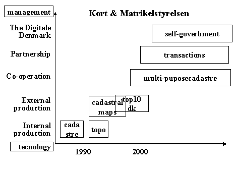
The horizontal axis in the model represents the time. In the first stage the main focus is on servicing the organization itself. The next step is servicing the society in general and the goal will be to give special service to the individual citizen. The boxes represent the activities to a given time, or if you like it in that way the different stages of development the individual organization will run through. The different activities can partly go on in parallel, but shortcuts are not possibly. Firstly we establish a technical solution and convert our data from analogue to digital form. Then we will harmonize our data, introduce standards, common datamodels, etc. After that we will integrate data and in this way create information, and soon we will create interaction with the individual citizen. The vertical axis represents the necessary primary professional competence for the different stages of development. The difference on being responsible for digitalization and harmonizing, modelling and visualisation is big. Seen from the point of organizational development each of the phases are very interesting. As it will be shown afterwards the order of the different phases may change from organisation to organisation and/or from country to country. The fact is that we at the same time are going through a migration phase and are adjusting ourselves to be marked oriented. It is interesting to observe that similar changes pass off as well in developed countries, as in developing countries and countries in transition. "Best practice studies" of actual developments concerning spatial information in public organizations and/or agencies would show:
The different organizations do not have to go through all the phases. Many starts with letting one or more technicians purchase equipment for digitalisation and conversion of data. In those cases there is great risk that the technicians afterwards will sub-optimize in order to protect their own position of power. The organizations would develop faster if they changed the focus from production to utilization. The best would be to start with developing a strategy for the future use of data and information. Presumably it would be more profitable to outsource establishment and conversion. 3. REALIZED DEVELOPMENTSWith another simple model I will illustrate some realized and some foreseeable courses of events and/or developments. Developments that support my assertion on need for changes in and introduction of new competence. The model is so general and robust that it can be used as well on one organization with several departments as on a number of institutions independent of the stage of development.
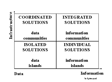
The horizontal axis illustrates the migration where focus change from data to information. The goal is to become a member of the Information Community, the situation represented with the top-right box. For many it is surprisingly hard to become an ordinary member of the elite, the information community. Some try to take a short cut. Unfortunately they must accept that short cuts often results in extra work. It is quite normal to move horizontal from left to right in the boxes at the bottom of the model. As soon as the organization has finished the creation of digital data, or even before, they wish to create information and at the same time make the information available, at least in house. Often the skilled technicians, who have been responsible for the establishment or conversion-phase, want to crown the achievement a web-solution. At the first glance the results are elegant, but in reality they are only useful in-house. Because the background is a data island they have create a new island, an information island. After a short while users outside the organization would like to use your information together with data from others. But it is not that easy to follow a vertical track from information-islands to information-communities. Quite normally it is difficult and often impossible to combine information from different sources. The most efficient action is to step back to the data-island and start to negotiate with the organizations you would like to co-operate with. We need to create harmony between the different data-sources. We must create an infrastructure for spatial data. This is not a job for inveterate technicians or GIS nerds. Instead we need people in the arena with political and organizational flair. People with knowledge on human nature and handling of information will create the vertical left track from data-islands to data-communities. They will establish the background for creating the data communities. With the data-communities as the necessary back-bone it is possible to create information that fulfils the needs of the different users. We can follow the horizontal track from the left to the right in the upper row. 4. SPATIAL DATA/INFORMATION INFRASTRUCTUREThere is no unified or accepted definition of Spatial Data Infrastructure. The content of a Spatial Data Infrastructure is dependent on and shall reflect the stage of development and education in the individual country. I will illustrate the concept of an infrastructure with a model, I developed some years ago.
The starting point for a common spatial data infrastructure is the smallest intersection of data and a set of "Highway Codes" for the vertical "Information Highway". The highway codes will comprise standards, data models, exchange formats, meta-databases, agreements on common object definitions etc. The actors will be organizations, agencies, public and private business and citizens who have a need for creating information crossing the established boundaries and structures. If you would like to read more about National Spatial Infrastructure I can warmly refer to the research of Professor Ian Masser from the ITC in Holland. 5. DEVELOPMENT OF AND CHANGE IN COMPETENCEThe individual organization should be prepared for requirements or needs on new competence, just as it will be appropriate/necessary to review and re-estimate the organization as such from time to time. This process requires involvement from the top-management. To illustrate the dependencies between the different stages of development and competence I’ll show you what has happened to the National Survey and Cadastre Denmark (KMS) over the last ten years. The period where we converted our maps to digital form and entered the marked for digital data and information.
The developments are represented in the boxes. The box with "transactions" represents what will happen late 2000 when the private licensed surveyors begin to use the new Cadastral Information and Updating system (MIA). Self-government is about the situation where the individual citizen is able to serve himself through an Internet and/or WAP or digital TV solution. The change has been driven through a number of developments and changes of the entire organization, upgrading and change of competence, recruitment of new employees, etc. In 1992 the process started seriously with a 20% staff reduction. The derived savings financed outsourcing of the digitalization process. You can look at this as a process of developing the private sector. Since 1992 the staff profile has changed markedly. A change from craftsmanship to handling functions such as preparation of invitations to tender, contract negotiations, quality control, product development, establishing of partnership, consultancy and sale, etc. 6. THE EDUCATIONAL CHALLENGE.As shown in the previous there is an increasing need for persons with knowledge on infrastructure elements, analysis, modelling, visualization, negotiation, management etc. Persons who are less skilled in the technical disciplines than the traditional surveyors. The demands on "management" skills depend on the stage of development for the organization. As soon as you start to co-operate with none professional users you need a staff who are able to handle information and knowledge. A study of the ongoing development results in some general observation:
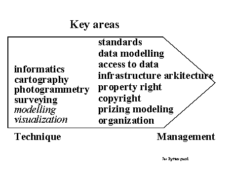
The traditional employee with a medium or high level education in geo-related issues do has a comprehensive knowledge on IT and informatics, cartography, photogrammetry and surveying.
New technologies will give us new methods for data capture. Remote sensing will give us cheaper data. Real time positioning will revolutionize the traditional fieldwork, etc. In time with the new technologies new actors will enter the stage. Physicists, mathematicians, statisticians and other professionals will be involved in data capture traditionally done by surveyors. On the other hand there is a need for employees with new qualifications such as management, standards, data models, meta data, access to data, infrastructure architecture, intellectual property right, copyright, prizing of data and organizational developments. At the same time there is a need for knowledge on analysis, modelling, visualization, visual communication a.s.o. The problem is that it is difficult to find an appropriate education. Normally there is a discrepancy between actual needs and the possible curricula. A number of the developing countries and some countries in transition are facing problems such as capacity building and the lack of a developed private surveying community. They experience an intensive brain-drain. Often when people are educated to a certain level they leave the country for a country with a higher living standard. In this way the individual country becomes very dependent on international consultancies and contractors, and it becomes nearly impossible for surveyors to establish the basis for sustainable business. Education is a real bottleneck. It is very urgent to establish sufficient possibilities for education and training on all professional levels. Especial the developing countries should be very much aware of the distance learning activities in some of the former eastern European countries.
7. CONCLUSIONSOften development and implementation of information systems is looked at and presented as a technical challenge. The hypothesis in this paper is that in connection with establishing information-systems involving one or more institutions or agencies the organizational problems turn out to be very fundamental, whereas the traditional technical aspects are of secondary importance. As previously mentioned other professionals than surveyors are and will be involved in data-capture. On the other hand there is recognition of the need for professionals who can take the responsibility for establishment of the necessary infrastructure – spatial information managers. It is an enormous challenge for universities and technical high schools to adapt their curriculum to needs and demands already recognised. If the educational institutions are able to produce candidates who understand and are able to handle spatial data and information infrastructure, harmonisation and integration of data there are enormous possibilities for employment. Besides the traditional production of candidates, there is a need for upgrading of surveyors with some years of professional experience. It is urgent to put focus on activities like continuing professional development and distance learning and training. It is extremely essential to secure that the curriculums reflect what is coming to morrow, instead of what happened yesterday. 8. EPILOGUEThere are a lot of examples on data-islands. Some information-islands and a few information communities are realities. In line with establishing of formal or informal national infrastructures for spatial data and information we will see many real information-communities. What happens then? Some will be disappointed because the none-professional user does not understand what we offer him. He or she lacks the knowledge we as professional intuitive use when we interpret the information we have created. We must offer our knowledge and our experiences. We must create knowledge-based systems. The American vice-president Al Gore speaks about: "Information at your fingertips" and about virtual travelling in space and time. This is only practicable to live up to if we are able to manage the challenge to offer our knowledge in a systematic and understandable way and if we can manage to make all historical data available in digital form. Without the historical aspects our collections of information will be like torsos. Jes Ryttersgaard 25 April 2000 |
||


